
Description
NAVIGATE THE UNFORGIVING
Built for high speed and high performance, this rugged off-road chase navigator has the tools you need to stay on track and the communication technology to stay in touch with global satellite coverage. With Tread XL – Baja Chase Edition, youll know where your race vehicle is and be able to communicate and support your team if any challenges come up or if you need to coordinate repairs.
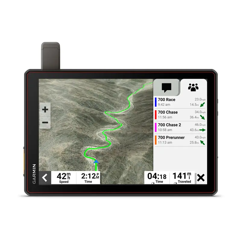
TEAM TRACKING
Team tracking with built-in inReach technology lets you see the live positions of your race vehicle and chase truck in real time with global satellite coverage. And you can easily send and receive messages to coordinate repairs. Requires activeinReach Flex Team subscription.
EASY PORTABILITY
The Tread Baja Chase Edition has a heavy-duty suction cup, vehicle power cable and robust, portable mounting hardware to easily move from one chase truck to another.
KNOW THE COURSE
Import the GPX data ahead of time to view the course start/end, racetrack line, all virtual checkpoints, pit locations and race mile markers.
PRERUNNING TOOLS
Prerunning tools let you create custom pacenotes such as sharp turn, stepdown or danger to help you anticipate obstacles and navigate the most efficient route through all virtual checkpoints.
TRACK YOUR TRUCK
When in chase mode, use your device to track a race vehicle with real-time updates on the map.
HIGH-PERFORMANCE GPS
Get enhanced performance with theexternal GPS antennaandexternal inReach antenna(each sold separately). Both are in low-profile, water-resistant housings and have many installation options.
CONTROL YOUR ACCESSORIES
Tread XL works with theGarmin PowerSwitchdigital switch box (sold separately) to control your vehicles 12-volt accessories, such as rock lights, fans and air pumps.
OFF-ROAD RUGGEDNESS
Purpose-built for all-terrain use, this Tread device stands up to desert temperatures and challenging terrain. Its alsoIP67-ratedfor dust and water-resistance.
TEAM TRACKING PLANS
Enjoy team tracking with unlimited SOS, text messages and more (requires activeinReach Flex Team subscription).
SATELLITE IMAGERY
Downloadable high-resolutionBirdsEye Direct Satellite Imageryshows vivid overhead views of your surroundings. Satellite imagery for the North Baja Peninsula comes preloaded on the device.
1Requires activeinReach Flex Team subscription. Some jurisdictions regulate or prohibit the use of satellite communications devices. It is the responsibility of the user to know and follow all applicable laws in the jurisdictions where the device is intended to be used.
Satellite Imagery 2022 Maxar Technologies (date of satellite imagery may vary).
| General | |
|---|---|
| Dimension | 9.9″W x 7.8″W x 1.2″D (25.2 x 19.9 x 3.1 cm) |
| Weight |
32.8oz (930 g) |
| Water rating | IPX7 |
| Display Type | multi-touch, glass, high brightness HD color TFT with white backlight |
| Display Size | 8.5″W x 5.3″H (21.7 cm x 13.6 cm); 10.1″ diagonal (25.7 cm) |
| Display resolution | 1280 x 800 pixels |
| Dual-orientation display | Yes |
| Magnetic Mount | locking magnet-assisted mount |
| Mount type | heavy-duty suction cup mount |
| 1.5″ ball adapter with AMPS plate | Yes |
| Drop rating | MIL-STD-810 |
| Dust rating | IP6X |
| Battery Type | rechargeable lithium-ion |
| Battery life |
Up to 6 hours at 50% backlight |
| Compatible with Tread XL Baja Dock accessory | Yes |
| Maps & Memory | |
|---|---|
| Preloaded street maps | Yes |
| High Definition 3D terrain | Yes |
| Data cards | microSD card (not included) |
| 3D Terrain | Yes |
| Internal storage | 128 GB |
| Ability to add maps | Yes |
| External memory storage | yes (256 GB max microSD card) |
| Includes map updates | Yes |
| Downloadable Satellite Imagery | yes (BirdsEye) |
| BirdsEye Direct Satellite Imagery | Yes |
| Sensors | |
|---|---|
| GPS | Yes |
| Galileo | Yes |
| Barometric altimeter | Yes |
| Compass | Yes |
| 10 Hz multi-GNSS positioning | Yes |
| Outdoor Recreation | |
|---|---|
| Point-to-point navigation | Yes |
| Preloaded topographical maps | Yes |
| Preloaded US public land boundaries | Yes |
| Preloaded private land parcel maps | yes (parcels greater than 4 acres) |
| Preloaded USFS Roads and Trails, including motor-vehicle-use-maps for motorcycle, ATV, SXS and full-size 4×4 | Yes |
| Navigate-a-track navigation | Yes |
| Turn-by-turn trail navigation | Yes |
| Camera Features | |
|---|---|
| Backup camera compatible | yes (BC 50) |
| Advanced Features | |
|---|---|
| Wi-Fi map and software updates | Yes |
| Adventure Features | |
|---|---|
| Built-in inReach Technology (requires active subscription; subject to regulations or prohibitions in some jurisdictions) | Yes |
| Pair with Garmin PowerSwitch digital switch box | Yes |
| Compatible with Group Ride Radio | Yes |
| Compatible with external GPS antenna with mount | Yes |
| Compatible with external inReach satellite antenna | Yes |
| Group Ride Mobile | yes (with Garmin Tread app) |
| Track recorder (breadcrumbs) | Yes |
| iOverlander points of interest | Yes |
| Ultimate Public Campgrounds | Yes |
| Birdseye Satellite Imagery (download via Wi-Fi) | Yes |
| Glove-friendly touchscreen | Yes |

Reviews
There are no reviews yet.